Home > Other Fun Stuff > Advocacy & Industry News

New Strava Metro Feature Shows Government How Cyclists are Using City Streets

19 Comments
Support us! Bikerumor may earn a small commission from affiliate links in this article. Learn More


Strava Metro is a new service that pulls from their database of activities, which they say is over 300 billion GPS points and growing, to give cycling advocacy groups and government organizations better insight into where people are biking in their cities. The goal is to help them make better informed decisions about alternative transpiration infrastructure like bike lanes.

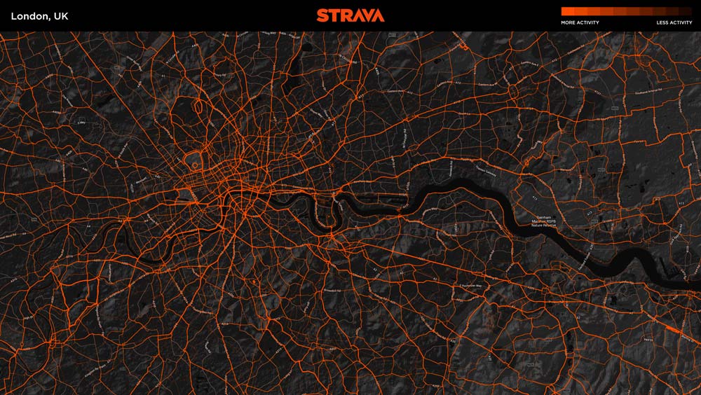
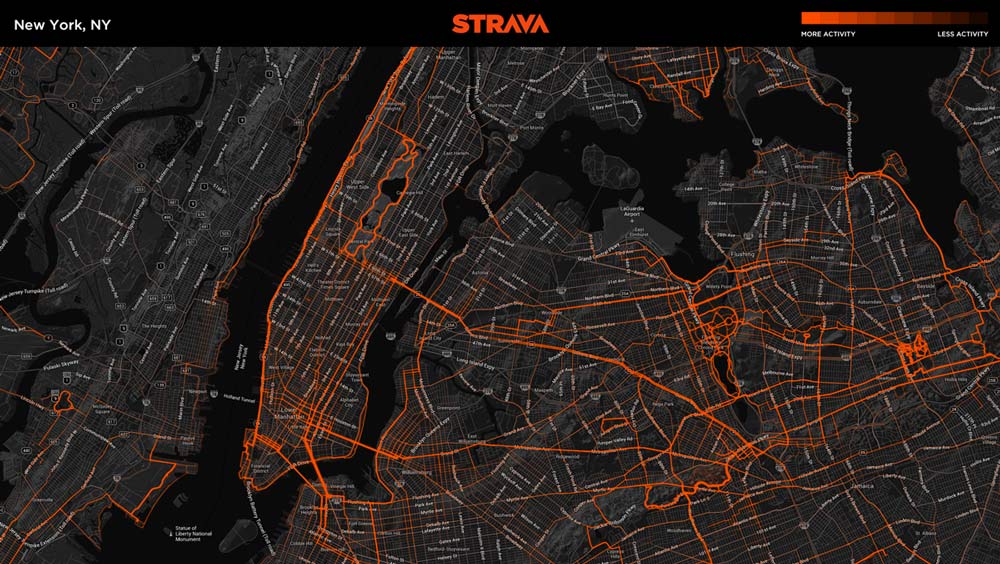
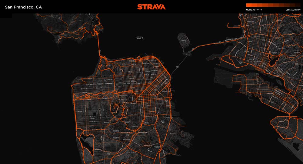
Perfect timing since next week is Bike To Work Week, which should provide a bit more data on how less avid cyclists might contribute to the load. Shown here are “heatmap” visualizations of Metro data for SF, NYC and London, illustrating the available data for some of the largest cities in the world.

Full PR at bottom…

strava-metro-heatmap-San-Francisco-CA

strava-metro-heatmap-London-UK

PRESS RELEASE: Strava, the online network connecting the global community of athletes, has announced Strava Metro, a new service that allows insight and analysis of bicycling routes and commute patterns around the world. The service empowers advocacy organizations and government agencies to understand cycling activity in local communities and make better-­‐informed decisions when planning, maintaining, and upgrading bicycling infrastructure.

Strava Metro leverages the activity uploads of millions of Strava members worldwide, anonymized and aggregated to protect privacy, to bring the process of collecting cycling traffic data into the digital age. With more than 2.5 million new GPS-­‐tracked activities added each week, Strava’s data set of over 300 billion GPS points offers an entirely new way of understanding and analyzing cycling traffic at a local level.

“Bicycling safety is a top concern to our members worldwide, especially when they’re riding through metropolitan areas with a high concentration of motor vehicle traffic,” said Michael Horvath, co-­‐founder and president at Strava. “Strava Metro delivers an innovative way for us to serve Strava members and non­‐members alike by helping to make their daily commutes and weekend rides smoother and safer.”

Organizations in the following areas are currently analyzing data from Strava Metro including the Oregon Department of Transportation and the cities of Alpine Shire, Australia; Arlington, Va.; Glasgow, Scotland; London, England and Orlando, Fla.

“Our goal is to provide a safe, efficient transportation system in Oregon which includes sustainable transportation options such as bicycling, walking and taking public transit,” said Margi Bradway, active transportation policy lead at Oregon Department of Transportation. “Strava Metro data will help us understand how and where cyclists are riding in Oregon, a critical component to evaluating the transportation system and planning for the future.”

Strava Metro is available today. Advocacy organizations and the general public can access high‐resolution heat map visualizations of the data free of charge.Organizations seeking deeper insight and analysis will be able to license Strava Metro data sets for use with geographic information systems (GIS) mapping software. Pricing is based on the number of Strava members in the requested geographic area. To learn more about Strava Metro visit metro.strava.com.
Subscribe
Notify of
guest

This site uses Akismet to reduce spam. Learn how your comment data is processed.

19 Comments
Oldest
Newest Most Voted
Inline Feedbacks
View all comments
ifbikes
ifbikes
10 years ago

very cool, thanks Strava!

Robo
Robo
10 years ago

This is great!

Axel
Axel
10 years ago

How many regular commuters are using Strava? I dont think this would very useful when planning for everyday commuting for “normal” cyclist…

David R.
David R.
10 years ago

Vote with your feet!

Garett
10 years ago

@Axel – I use Strava for all of my 14-mile commute rides. It helps me track my performance, and more importantly, my overall mileage. If nothing else, it’s nice to see all those short rides adding up to a lot of miles.

Eddie Snowden
Eddie Snowden
10 years ago

anonymized…

HaHahahahahaha…

bike=life
bike=life
10 years ago

This may be the best use for Strava yet!

Brian
Brian
10 years ago

Jessica Roberts in Portland has a strong rebuttal against this:

http://bikeportland.org/2014/05/01/odot-embarks-on-big-data-project-with-purchase-of-strava-dataset-105375#comment-4790733

I agree that if City planners understand the limitation of this dataset it *might* be useful in combination with other data. However, on its own it is simply a propensity map for above-middle-average 25-40 year old white guys.

Michael
Michael
10 years ago

Axel is right about this skewing to recreational cyclists. I do use the app for commuting, and recreational cyclists are also going to prefer safer roads. I would like to see an official statement from Strava addressing this. I believe they also have an option to flag your ride as a commute. Perhaps they are only using that data or weighting it more heavily.

Danny
Danny
10 years ago

I disagree with Alex and Michael. I commuted on my bike pretty regularly and always have Strava running (mostly to see total miles add up). The data could easily be filtered by time of day to account for primary commute hours. Additionally, why does this data only need to be used for planning for commuters. There’s a lot of bikes on the road and this data can be used to make riding safer for all…not just commuters.

Slow Joe Crow
Slow Joe Crow
10 years ago

Strava primarily shows where the spandex clad racer types hang out and the Portland Oregon heat map shows both very little traffic on some heavily used commuter routes and oddities such as a large stationary blob clustered around a gym where people are using their devices as heart rate monitors on stationary bikes.
As Bike Snob would put it, Strava data is most useful for telling you how to avoid Freds.

bikermark
bikermark
10 years ago

A cool data point. The point about Fred-bias is conceded, but this is still better than the alternative of some overweight traffic engineer, who hasn’t been on a bike in 30 years, deciding where the bike routes should go. That’s how it still happens in most US cities.

Next generation bike share data should prove to be better at showing where real people ride.

Robo
Robo
10 years ago

There’s a little tab when you upload your ride to make it a ‘commute’ assuming they looked at strictly THAT data (and assuming their users use it) it would make for some good info. Agreed it’s but a piece of the puzzle but, hey, we’ve got the technology, let’s use it….

Matthew
Matthew
10 years ago

bikermark has it spot-on: the data might be skewed, but it’s better than someone who doesn’t ride choosing where the bike lanes go. (For example, here in Seattle, the ferries are a major commuter hub, but the closest bike arterial is four blocks east, and up a hill with a 18% average gradient. Most cyclists leaving the ferry just use the parallel road that doesn’t go up that hill… and which will receive no bike funding).

For those of you who think that this data is useless because it includes racy-racy cyclist data, how difficult do you think it’d be for Strava to take their API, build another app with different colors and branding. This app then rewards the number of times/number of days you ride instead of how fast you ride, includes routing that minimizes hills and distance while riding over popular roads using their route planning feature from Strava, and is marketed to the “transportation cyclists”? The data from both apps could be easily combined and marketed as a single dataset.

Fattylocks
Fattylocks
10 years ago

Whats Strava ?

Kyle Polansky
Kyle Polansky
10 years ago

Neat Idea. However, I only upload my training rides to Strava. I never bother to record/upload my daily commute. The types of roads I use for commuting also tend to be different than the ones I use for training; Both in location and design type. And, like others have said, only a relatively small amount of people use Strava.

That being said, I’d be very happy if any bicycle projects were funded in my town. I guess more exposure is better than no exposure.

Collin S
10 years ago

Yes, the data will be skewed. It will highlight the best roads and if someone interprets it wrong, then they will avoid areas where there is no one riding thinking that there is no need when in reality, no one is riding it because its dangerous to ride on it. It will show voids of where infrastructure is non existent but is needed. For example, in my area of Metro Detroit, Telegraph is a very main artery but it would be nearly suicidal to try and ride on it, as its basically an interstate with a slower speed limit and traffic lights. On the other side of town, I275 is an actual highway, but there is a bike path that parallels the road. Its used extensively, and if you see the heat map, the 275 path would glow, but Telegraph would be blank. An urban planner could see this void and try and fill it.

Remember, its one of those whats good for the goose is good for the gander. If you improve the infrastructure for the elite cyclist, your freds, commuters, and those who bike out of necessity not for lux (IE most people on strava) will also use these roads/paths and life will be better for all.

Scott
Scott
10 years ago

Great Strava is compiling Data for NSA and you local Police State.

Brian
Brian
10 years ago

This has been an insightful chain of comments and we really do value all of the feedback. Since the release of this article Strava has launched its public page. If you are interested in hearing more about what we are doing you can visit http://metro.strava.com/faq/

On a personal note, please know that we do take Strava users privacy very seriously and that Strava Metro is built in a very specific way that takes the many and blends it to one. This is not raw data that is being provided back to planning groups but years of well thought out data structure.

I know that by blending all of our efforts together we can make the globe a safer place to ride.

Cheers

Subscribe Now

Sign up to receive BikeRumor content direct to your inbox.