Home > Other Fun Stuff > Gadgets & Hacks

Sherpa Map Highlights Gravel Roads & Weather for Free

sherpa map cycling mapping app and online service with gravel road detection and free weather mapping
11 Comments

Looking for a free mapping service that loves gravel as much as you do? And has free AI route creation? And can help you steer clear of bad weather? Did I mention it’s free?

Sherpa-Map is an upstart from Eric Semianczuk and friends, and it’s a pure passion project. But they say it’s built on the same GraphHopper backend as RideWithGPS and Komoot. Then they add some fun features, the most exciting one being predictive gravel mapping.

Sherpa Map shows where the gravel roads are in an area

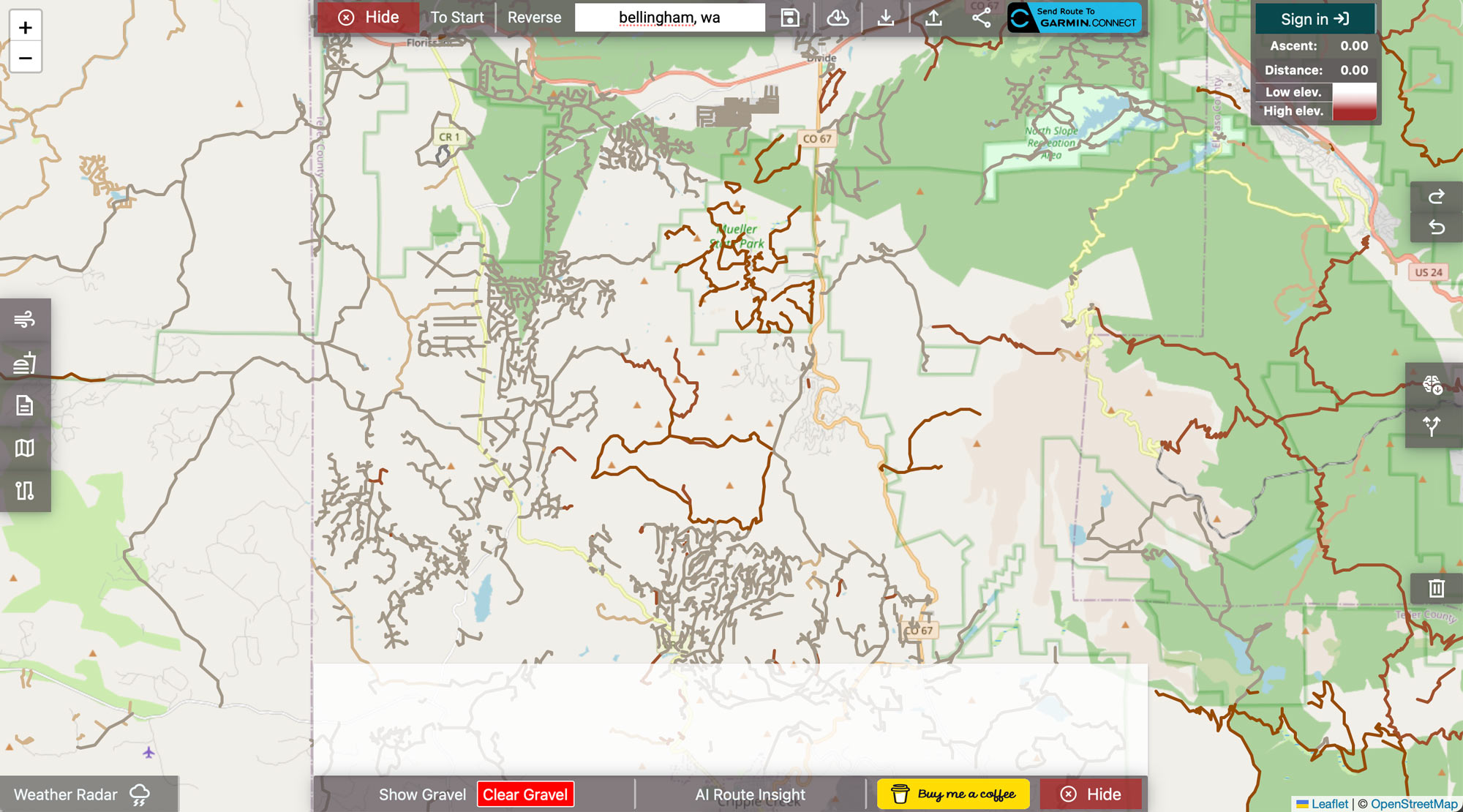
By applying AI to satellite imagery, Sherpa-Map figures out which roads are likely gravel or dirt, then lets you add an overlay to the map so you can route through as much as you can. You can even ask it to try to identify unknown surface types in areas you want to explore.

Sherpa Map cycling routing on the map with color coded elevation profiles

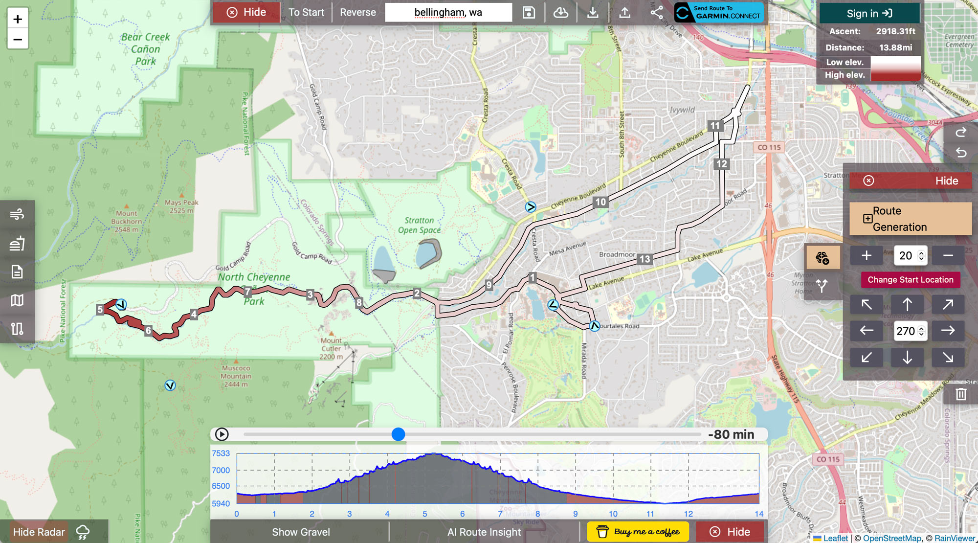
Their route creation tool is unique, too, letting you choose the distance and general direction, then having it generate some options. It cleverly color codes the route line to indicate elevation change, too. Check their demos here.

It can even help you preview the weather (details here), so you can route around rain or storms. It’ll show recent historical weather and a live radar, and can even show the predicted tailwind all along your route. Wanna set a PR or nab that KOM/QOM? Use the wind to your advantage when selecting the day’s conquest.

sherpa map cycling mapping app has AI route descriptions
How’s that for an AI-generated route description?

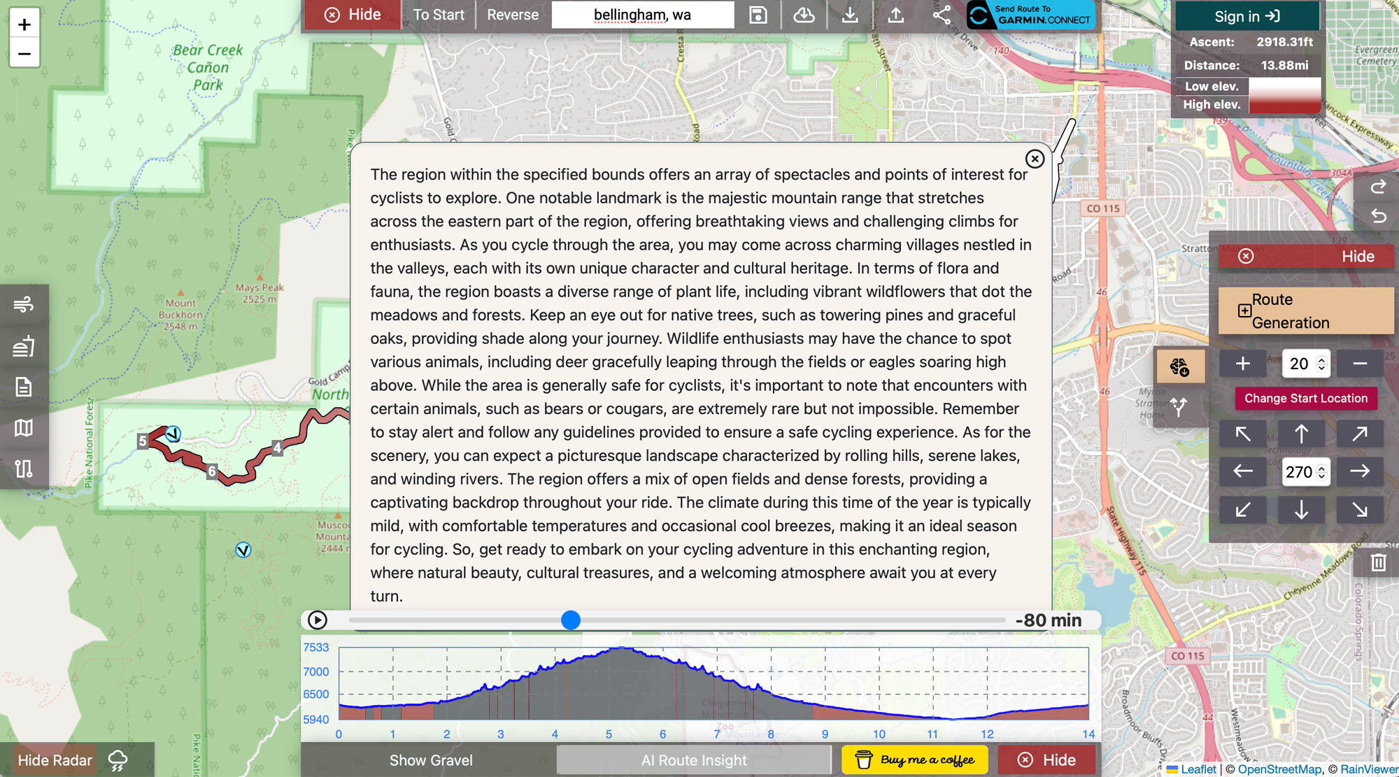
The project is small for now, but it already supports 28 routing profiles, the ability to automatically generate routes, send routes to Garmin, support Google Maps/MapBox/Open Street map, ChatGPT route insight, get street view/Google directions, and more.

There’s a Buy Me A Coffee donation button if you try it and like it, which will help them grow into their bolder plans of launching iOS/Android apps for live, turn-by-turn routing (already in development). Definitely worth checking out.

Sherpa-Map.com

Subscribe
Notify of
guest

This site uses Akismet to reduce spam. Learn how your comment data is processed.

11 Comments
Oldest
Newest Most Voted
Inline Feedbacks
View all comments
Andrew Lee
Andrew Lee
7 months ago

I discovered this a few months ago and have been using it for all my gravel rides. I love it!

syborg
syborg
7 months ago

I don’t see the connection between the Sherpa people in Nepal and “gravel” bike riding.

TheStansMonster
TheStansMonster
7 months ago
Reply to  syborg

Because “sherpa” has become colloquial for someone or something that helps. I’m not saying it’s right or appropriate, but it is pretty obvious if you aren’t being deliberately obtuse.

Oliver
Oliver
7 months ago

Tried it on some areas around me … it detects maybe 5% of dirt. Seems to be useless in its current state.

Eric Semianczuk
7 months ago
Reply to  Oliver

Hi Oliver, I feel you, as I live in North America there could certainly be more road surface data. When creating a route you can manually press the “define unknown” button to immediately request AI surface classification, I’m working on defining all unknown roads, but… there’re millions… Here’s a little how-to on the manual option: https://i.imgur.com/ycs7pEe.mp4

Tyler
Tyler
7 months ago

A suggestion for Eric and team:

Try to leverage the heatmaps of Strava and Garmin (surprisingly less built-out for gravel, despite Unbound/proximity to Emporia), to help assess the safety and ability to traverse the gravel roads in an area.

This is what I do when trying to plan a gravel route in a new area – see what others have already ridden.

Eric Semianczuk
7 months ago
Reply to  Tyler

Solid point, I’ve used Strava’s heatmap for ages and queried Garmin’s team when I was implementing the “send to Garmin” functionality, Garmin doesn’t provide any API access to their heatmap. Strava also doesn’t have a direct API functionality, but there are ways to access the tiles through various other services, similar to how Gpx-Studio or Trail Router accesses it. I’ve been researching these methods, and researching Strava’s terms to ensure compliance (I’ve reached out several times and have never received a response, but I’m determined!)

Beyond this, I’ve thought of letting users upload a KML file of Google Timeline data, parsing out ride data, and showcasing this on a person-by-person heatmap.

I will also happily add this functionality to the Android/IOS mobile apps I’ve been working on, there would be nothing more satisfying than seeing a heatmap grow!

Tyler
Tyler
7 months ago

I’m tinkering with it a bit more now. I noticed that it doesn’t seem to recognize rail-trails as viable routes. A little more than half of the rail-trails near me, are essentially gravel, and frankly the safest routes around.
I think the heat maps or other local bike trail network maps, would help tune the results to this kind of route.

Eric Semianczuk
6 months ago
Reply to  Tyler

Interesting, I use the same Open Street Map data that practically everyone else uses to identify which roads/trails/etc. are bikable.

There’s a chance that these trails are either not in the database or are marked as footpaths only. I’d imagine it’s the latter if they’re routable on other services that support running/hiking profiles.

I’ll have to look into solutions that allow users to easily identify roads that need to be either added or updated, there is a rather strict process to do that in Open Street Map, but I can potentially create a pseudo process that just updates the navigability of said portions on my site after a quick approval.

Regardless, great feedback! If you’re willing to share the specific trails that are not navigable at this time I’ll see what I can do to import them into Open Street Map and/or troubleshoot further.

Tyler
Tyler
6 months ago

If you’re willing to continue conversing via email, and value my inputs, I’d be happy to give you many more and continual local insights.
I’m in Kansas – home to some of the best gravel racing there is, but also a place in need of better gravel navigation resources, especially outside of the area surrounding Emporia where the popular Garmin Unbound race is.

VazzedUp
VazzedUp
7 months ago

For the UK, Cycle.Travel is a great site as it uses national cycle network routes, and regional routes to keep you off busy roads. You can set it to road type of Any, Paved or Gravel and it will adjust, also provides a distance used for each surface. Used it for helping to plan a 3 day route in the south of England kept me on quiet lanes, bike tracks, canal towpaths and away from main roads.
Also used GPX Studio to tidy up files or to piece together multiple gpx files.

Subscribe Now

Sign up to receive BikeRumor content direct to your inbox.

Subscribe Now

Sign up to receive BikeRumor content direct to your inbox.